Finally, what I've been waiting for. A reason to replace my Garmin Zumo. Which may not happen immediately, but I foresee this as a really, really great tool.
I know, I just published my Garmin Zumo 390 review but now I found what I have been searching for! An iPhone app that lets me import the GPX file I need from Furkot and then it reads the turn by turn directions into my Sena SMH10R.

This iPhone app is called InRoute Route Planner. It's a free app but it comes with optional upgrades, which I'll gladly pay for. The free version allows for up to 24 locations in a particular map I think. It's $2.99/month or $24.99 for the year if you want up to 100 locations per map. So I went ahead and bought a year. Why not?
If I can successfully use this app for all my turn by turn navigation, then adios Garmin! Fingers crossed, as we leave for Port Jervis in the morning on a quick overnight :)
Update August 2016
I've now been using the InRoute app exclusively for the past two months. It has definitely done its job and very well, I might add.
There are two things that I've wanted my phone to do for me; navigate and then give me turn by turn directions through my Sena SMH10R Headset so I don't have to look down or check to see what the display is showing. Although it has some minor issues to resolve, overall its the best navigation option I've ever used.
Back in June my husband and I ventured north to Port Jervis, NY. We left early Sunday morning and then headed up to the border as far as we felt like going. Then we grabbed a hotel for the night once we got into New York.
Opening GPX Files
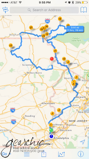
The photo above is the ambitious ride route I laid out for us. You can download a copy of the GPX file here. :) All you have to do is either create a route on a website such as Furkot.com, save it as a .GPX and then open it easily on your iPhone (there are others I'm sure, just use whatever site or software application you want to create the GPX). (Or, alternatively you can create a route on the fly right inside the app. We'll get to that part in a bit, so keep scrolling if you want that part.)
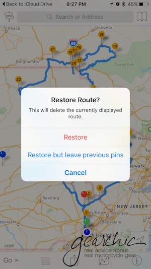
I use iCloud Drive (in addition to Google Drive) so all I have to do is open my file. Once you create the GPX on your desktop, you could also just email it to yourself too. Once I've found my file, I just tell my phone how I want to view it.

In this instance, I want it to "copy to InRoute". If I already have another route or map open, it'll ask me if I want to Restore Route. I Choose Restore.
And then voila! I have my ride route. All I have to do is hit GO and we're off. My Sena starts talking to me and I'm ready to ride.

Creating Routes on the Fly
However, sometimes you just need to make a quick route without a computer nearby. This is my favorite feature. I can instantly create a route, tweak it and then share it with my husband so he can also lead part way. It's as simple as putting your finger exactly where your destination is. As soon as you do, it asks you if that's going to be your Start, a Waypoint or your Destination. For this example, I choose Destination.

But I really really really don't want to take the turnpike there. And this map much like other maps might assume you do. No Thank You. Maybe I want to visit the infamous stretch of road where I lowsided last year to see if they patched up the entire roadway or not. So I place my finger at on the road and it drops a pin. I select Waypoint.

Now, we have a decent route!

But let's just say that I want to make another stop along the way, just for fun.

Crap. Now things are in the wrong order. No problem :) Click on the little 2Way Sign in the upper left corner.

Now you have this handy option to Optimize Waypoint Order. SO handy. You can also rearrange points manually here too. If you select a particular point you can then delete it.
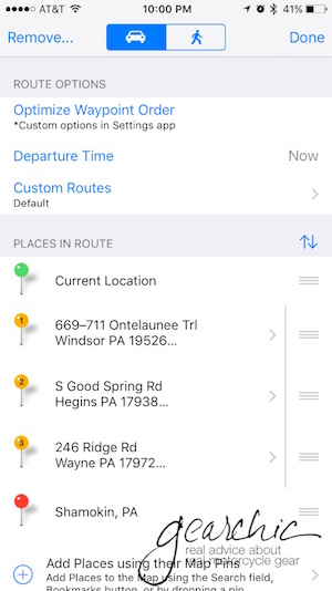
Now that I've rearranged the order, I have a proper route.

Then when it comes to sharing this route with the man, I just text it to him like any other image or file on my iPhone.
The only downsides of the app that we've discovered are:
- It uses the Apple Maps Engine. For some reason, and I'm not quite sure why, it won't interrupt my intercom conversation with my husband to give me the directions. I have to toggle back to my phone to hear it. I'm ok with this for now, because it's a small sacrifice to have a much better app interface such as this. Google Maps and Waze don't do this, so it's definitely possible and most likely a feature they have to program into the app (something about APIs to tell the phone that it's an incoming phone call, not just music - per my mobile app developer expert husband).
- The Northeast is full of roads and highways with multiple names. Look at this one for instance. You can see that Route 143 is also known as "Ontelaunee Trail". It might tell me one or the other, so I have to trust it when it tells me to turn somewhere. It doesn't always do this, but often enough that I try not to worry as much if I'm turning at the right point.

A couple of fun features is that it offers temperature, humidity and a few other details along your route, super handy.

Those are the main features that I use on the app. I'm sure I'll discover more as I use it further.
Other than those two details, I don't foresee going back to the Zumo anytime soon. The only thing I still might need is a waterproof case which is easy to come by.
In order to have my phone easily accessible on the bike I purchased this Ram Universal X-Grip cellphone holder. All I had to do was take off the Garmin Mount from the Ram Arm and swap it for the X-Grip.