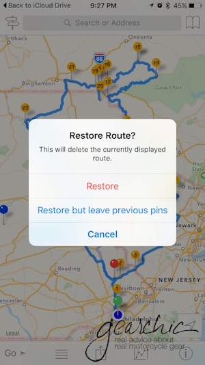
This iPhone app is called InRoute Route Planner. It's a free app but it comes with optional upgrades, which I'll gladly pay for. The free version allows for up to 24 locations in a particular map I think. It's $2.99/month or $24.99 for the year if you want up to 100 locations per map. So I went ahead and bought a year. Why not?
If I can successfully use this app for all my turn by turn navigation, then adios Garmin! Fingers crossed, as we leave for Port Jervis in the morning on a quick overnight :)
Update August 2016
I've now been using the InRoute app exclusively for the past two months. It has definitely done its job and very well, I might add.
There are two things that I've wanted my phone to do for me; navigate and then give me turn by turn directions through my Sena SMH10R Headset so I don't have to look down or check to see what the display is showing. Although it has some minor issues to resolve, overall its the best navigation option I've ever used.
Back in June my husband and I ventured north to Port Jervis, NY. We left early Sunday morning and then headed up to the border as far as we felt like going. Then we grabbed a hotel for the night once we got into New York.
Opening GPX Files
The photo above is the ambitious ride route I laid out for us. You can download a copy of the GPX file here. :) All you have to do is either create a route on a website such as Furkot.com, save it as a .GPX and then open it easily on your iPhone (there are others I'm sure, just use whatever site or software application you want to create the GPX). (Or, alternatively you can create a route on the fly right inside the app. We'll get to that part in a bit, so keep scrolling if you want that part.)
I use iCloud Drive (in addition to Google Drive) so all I have to do is open my file. Once you create the GPX on your desktop, you could also just email it to yourself too. Once I've found my file, I just tell my phone how I want to view it.

